A plat map is a detailed drawing that outlines property subdivisions, showing boundaries, lot numbers, and street layouts, primarily used for real estate and municipal planning. In contrast, a survey provides precise measurements of a property's boundaries and features, conducted by a licensed surveyor to identify exact dimensions and potential encroachments. Understanding the difference between a plat map and a survey is crucial for property owners, buyers, and real estate professionals to ensure accurate land descriptions and avoid disputes.
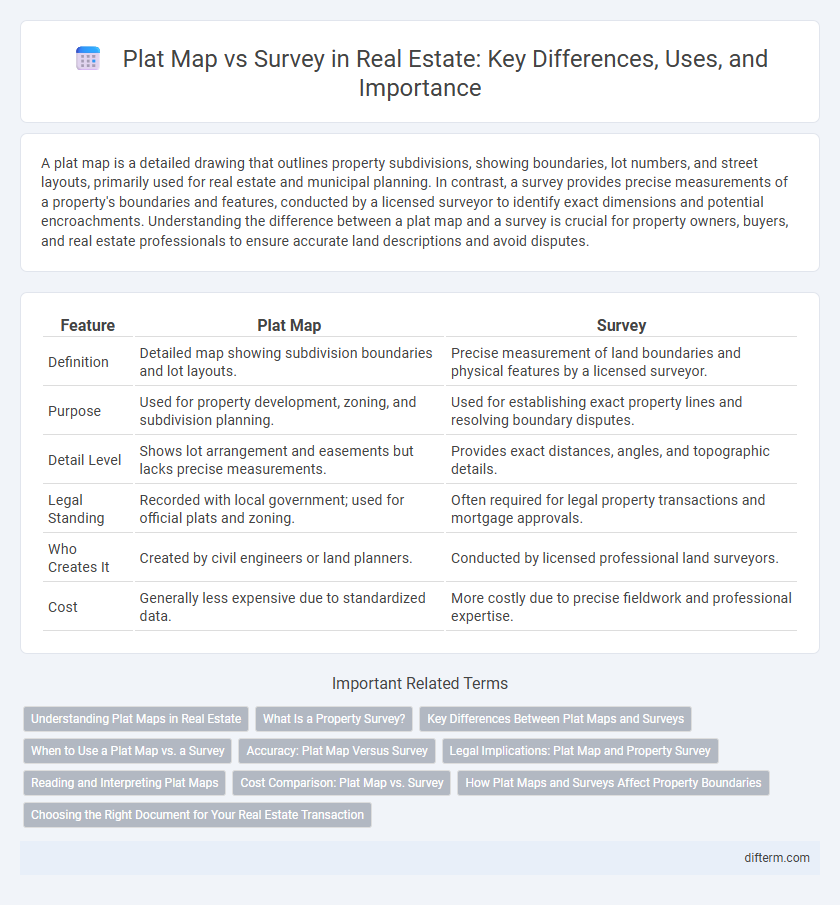
Table of Comparison
| Feature | Plat Map | Survey |
|---|---|---|
| Definition | Detailed map showing subdivision boundaries and lot layouts. | Precise measurement of land boundaries and physical features by a licensed surveyor. |
| Purpose | Used for property development, zoning, and subdivision planning. | Used for establishing exact property lines and resolving boundary disputes. |
| Detail Level | Shows lot arrangement and easements but lacks precise measurements. | Provides exact distances, angles, and topographic details. |
| Legal Standing | Recorded with local government; used for official plats and zoning. | Often required for legal property transactions and mortgage approvals. |
| Who Creates It | Created by civil engineers or land planners. | Conducted by licensed professional land surveyors. |
| Cost | Generally less expensive due to standardized data. | More costly due to precise fieldwork and professional expertise. |
Understanding Plat Maps in Real Estate
Plat maps in real estate provide a detailed layout of property subdivisions, showing boundaries, lot dimensions, and easements, essential for understanding the legal divisions of land. Unlike surveys, which are precise field measurements conducted by licensed surveyors to confirm property lines, plat maps offer a recorded graphical representation used in public records and development planning. Mastering plat maps helps investors, developers, and homebuyers verify parcel boundaries and zoning information critical for property development and transactions.
What Is a Property Survey?
A property survey is a detailed, professional measurement of a parcel of land that identifies precise boundaries, easements, and improvements relative to the lot. Unlike a plat map, which is a recorded document showing subdivision boundaries and lot dimensions, a survey provides real-time, accurate data tailored to a specific property. This critical tool ensures legal clarity for property ownership, construction, and dispute resolution in real estate transactions.
Key Differences Between Plat Maps and Surveys
Plat maps provide a general layout of property boundaries, streets, and easements within a subdivision for public record, while surveys offer precise measurements and detailed property lines performed by licensed surveyors. Surveys include exact dimensions, topographical features, and improvements on the land, making them essential for legal property descriptions and resolving boundary disputes. Plat maps are typically used for planning and development purposes, whereas surveys are critical for property sales, construction, and securing financing.
When to Use a Plat Map vs. a Survey
A plat map is ideal for understanding property boundaries, subdivision layout, and street locations in residential developments, especially during the initial stages of land purchase or development planning. A survey provides precise measurements and detailed property boundary verification, crucial when resolving boundary disputes, constructing improvements, or finalizing legal property descriptions. Real estate transactions, zoning compliance, and land use planning often require both documents to ensure accuracy and legal clarity.
Accuracy: Plat Map Versus Survey
Plat maps, created by government agencies, provide a general outline of property boundaries and lot divisions but often lack precise measurements. Surveys, conducted by licensed land surveyors, deliver highly accurate boundary details and pinpoint exact property dimensions using advanced tools like GPS and total stations. For legal purposes, disputes, or construction projects, surveys offer superior accuracy compared to plat maps, ensuring definitive property lines.
Legal Implications: Plat Map and Property Survey
Plat maps provide a general overview of property boundaries and subdivision layouts approved by local authorities, often used in initial property transactions and record-keeping. Property surveys, conducted by licensed surveyors, offer precise measurements and identify any encroachments or easements, serving as legally binding documents in disputes or title clarifications. Legal implications of relying solely on plat maps include potential boundary inaccuracies, while certified surveys are essential for resolving title issues and ensuring compliance with zoning laws.
Reading and Interpreting Plat Maps
Reading and interpreting plat maps is essential for understanding property boundaries, subdivision layouts, and easements in real estate transactions. Plat maps depict property lines, street locations, and lot dimensions in a graphical format that aids buyers, sellers, and developers in visualizing land divisions. Unlike detailed surveys, plat maps provide a broader overview but require careful analysis to ensure accurate boundary identification and assess legal descriptions.
Cost Comparison: Plat Map vs. Survey
Plat maps typically cost between $200 and $500, making them a more affordable option for identifying property boundaries and lot dimensions. Surveys, on the other hand, can range from $500 to $1,500 or more, depending on the property's size, location, and complexity, providing precise measurements and detailed boundary information. Understanding the cost differences helps property buyers and developers determine which documentation best suits their needs and budget.
How Plat Maps and Surveys Affect Property Boundaries
Plat maps provide a visual representation of property boundaries, subdivisions, and easements, serving as a foundational reference in real estate transactions and development planning. Surveys offer precise measurements and detailed descriptions of property lines, identifying encroachments, boundary disputes, and topographical features critical for accurate legal documentation. The combination of plat maps and surveys ensures clear property boundary definitions, minimizing conflicts and supporting informed decisions for buyers, sellers, and developers.
Choosing the Right Document for Your Real Estate Transaction
A plat map provides a detailed overview of property boundaries, streets, and easements, making it essential for understanding neighborhood layouts and zoning compliance. A survey offers precise measurements and identifies physical markers on the property, critical for resolving boundary disputes and verifying lot dimensions. Selecting the right document depends on your transaction needs: use a plat map for general planning and a survey for legal verification and title clarity.
plat map vs survey Infographic